Saturday, January 21, 2017
The Hypraptive BearID Project
I started working on a new project combining two of my interests: wildlife and machine learning. The goal of the project is to build a facial recognition system for brown bears which can be used by researchers in conjunction with camera traps and citizen science to non-invasively track and monitor populations. The project, BearID, is open source on GitHub and I'm writing about it on the hypraptive blog.
The most recent post is FaceNet for Bears.
Saturday, December 31, 2016
African Safari Photo Albums
Photo Album List:
Tanzania
Uganda
Rwanda
Kenya
- Lake Manyara
- Gibbs Farm
- Maasai Village
- Olduvai Gorge
- Serengeti National Park
- Ngorongoro Conservation Area
- Kibale National Park
- Queen Elizabeth National Park
- Bwindi Impenetrable National Park
- Ngamba Island Chimpanzee Sanctuary
- Kampala
- Miscellaneous
Wednesday, December 7, 2016
South American Expedition Photo Albums
Photo Album List:
- Ecuador Mainland
- Galapagos Islands
- San Cristobal
- Genovesa
- Bachas Beach and Cerro Dragon (Santa Cruz)
- Punte Vicente Roca and Bahia Urbina (Isabela)
- Fernandina and Isabela
- RĂ¡bida
- Tortoise Camp (Santa Cruz)
- Santa Cruz
- Peru
South American Expedition
In July of 2016, I booked the trip of a lifetime for Mary's upcoming birthday.
Sunday, July 6, 2008
Wednesday, August 1, 2007
Lakes Trail (Sequoia National Park)
Mary and I went backpacking in Sequoia over the weekend of July 28-29. This time it was just the two of us. We wanted to test out our new gear, including:

We got to the Lodgepole Ranger Station around 9:45 AM. Only 7 of 25 permits had been assigned so far, so we were able to go for the Lakes Trail. The trail is around 6 miles each way with about 2200 feet of elevation gain. It passes 4 different lakes with campsites and toilets at two of them. Our goal was the 4th lake, Pear Lake.
We set off from the trail head at Wolverton at around 10:40 AM. The weather was beautiful as we hit the trail and entered the forest. The first part of the trail makes a steady climb up a moraine deposited by an ancient glacier. The trail heads up to a ridge along the Tokopah Valley. From the ridge you can see the Lodgepole Visitors Center. Continuing along the trail we saw a log with some amazing orange mushrooms growing on it's side. At about 2 miles we reached the junction for the Watchtower/Hump Trails. We choose the Watchtower Trail.
The Watchtower Trail is slightly longer than the Hump Trial, but it is also flatter. That aside, it also provides some spectacular views. We stopped for lunch near the top of the Watchtower and had great views of the Tokopah Valley. We should probably have eaten a better breakfast because we were both starving by the time we stopped for lunch. We scarfed down our sandwiches and tomatoes in no time. Man did that taste good! I was a bit confused about the Watchtower, because the picture in the trail book was from the bottom, but we were at the top.
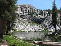
The trail followed along a cliff. There were more stunning views of the Tokopah Valley and Tokopah Falls (though there wasn't any water flowing at this time of year). A bit further along, at about 4 miles, we reached the first lake, Heather Lake. The banks of this lake are lined with red heather and various other trees and plants. We saw a few people swimming and a few more fishing. There's no camping allowed at Heather Lake, but I think it would make a great day hike destination.
From Heather Lake the trail heads up another ridge. We were keeping our eyes peeled for marmots and pika as they are supposed to be numerous along this part of the trail. Maybe they're not very adventuresome during the hottest part of the day because we didn't see much. We did spot a pika or two darting among the rocks, but didn't manage to capture any with the camera. After crossing the ridge we had a great view of Aster Lake. Emerald Lake at mile 5 is not visible from the trail so we decided to save it for tomorrow and continued on.
We had one more ridge to cross to get to Pear Lake. Again we were awarded with some amazing views up the Tokopah Valley and had a better view of the Watchtower (the point just left of center in the picture on the right). There are still a variety of flowers in bloom along the trail. We saw a few hummingbirds buzzing about along this section. After crossing the ridge we arrived at Pear Lake around 4 PM.
Upon arriving at Pear Lake we looked around to find a good campsite. The campsites here are numbered and you are only allowed to camp in a numbered space. We eventually settled at site #2 just across the small creek. They also have a couple compost toilets set up here which sure beats ducking behind a tree. We set up camp, filtered some water and started on dinner. Dinner was a bag of dehydrated beef stew. It wasn't too bad. Our new stove worked reasonably well.
We watched the shadows from the setting sun slowly creep up the Pear Lake basin. There was a nice alpen glow on the looming Alta Peak (picture right). There are no campfires allowed here, so we decided to turn in. I had a bit of a headache either from the altitude, dehydration or both. It made it difficult for me to sleep. I don't usually sleep all that well out camping anyway, but this was even a little worse.I did managed to doze off a bit over the course of the night. We were up again by 7:30AM.
Breakfast consisted of oatmeal and instant Vietnamese coffee. We had a few morning visitors including a marmot, a very cute pika (picture left), and a brave little golden-mantled ground squirrel. We had hung most of our gear in trees because of the warnings that the marmots like to chew on your salty gear. Fortunately the marmot we saw was eating a more natural diet. We enjoyed watching our visitors for quite a while, then finally packed up camp. After topping off our water bladders we were ready to head back out.
The hike out was much easier since it was mostly downhill. We really enjoyed the awesome views of the lakes and valleys. This time we took the short detour to see Emerald Lake, and it was worth it. I think Emerald Lake is even nicer than Pear Lake, and there are camping sites and a compost toilet there as well. Next time maybe we'll camp at Emerald Lake instead. We never did walk down to Aster Lake, but we had some nice views of the trail.
We saw more day hikers fishing and swimming at Heather Lake. Before we rounded the ridge by the watchtower, we took one final look back up the Tokopah Valley (picture on left).
The only real excitement on the way down was a loud crash that made us both jump. A small tree fell across the trail about 30 yards in front of us. It made quite a racket, but was easy to get around.
I made a map of the trail we took at Gmaps Pedometer.
Epilogue: We both really enjoyed this hike, though it was a bit more challenging than we thought. I guess we never give the altitude enough consideration. This was my first trip to this sort of altitude with a full pack. We were mostly happy with our new gear, though Mary had problems with her pack. The strange waffle pattern on the shoulder straps bruised her collar bone. She will most likely return it and try to find another one. It also seems that the BearVault BV350 may be a little small, so we may upgrade it to the BV400. Thank goodness for REI and their liberal return policy.
- My Deuter ACT Lite 65+10 backpack
- Mary's Osprey Aura 65
- A BearVault BV350 Solo bear canister
- MSR Pocket Rocket stove
- MSR SweetWater microfilter
- Platypus Water Tank (4L)
We got to the Lodgepole Ranger Station around 9:45 AM. Only 7 of 25 permits had been assigned so far, so we were able to go for the Lakes Trail. The trail is around 6 miles each way with about 2200 feet of elevation gain. It passes 4 different lakes with campsites and toilets at two of them. Our goal was the 4th lake, Pear Lake.
We had one more ridge to cross to get to Pear Lake. Again we were awarded with some amazing views up the Tokopah Valley and had a better view of the Watchtower (the point just left of center in the picture on the right). There are still a variety of flowers in bloom along the trail. We saw a few hummingbirds buzzing about along this section. After crossing the ridge we arrived at Pear Lake around 4 PM.
Upon arriving at Pear Lake we looked around to find a good campsite. The campsites here are numbered and you are only allowed to camp in a numbered space. We eventually settled at site #2 just across the small creek. They also have a couple compost toilets set up here which sure beats ducking behind a tree. We set up camp, filtered some water and started on dinner. Dinner was a bag of dehydrated beef stew. It wasn't too bad. Our new stove worked reasonably well.
We watched the shadows from the setting sun slowly creep up the Pear Lake basin. There was a nice alpen glow on the looming Alta Peak (picture right). There are no campfires allowed here, so we decided to turn in. I had a bit of a headache either from the altitude, dehydration or both. It made it difficult for me to sleep. I don't usually sleep all that well out camping anyway, but this was even a little worse.I did managed to doze off a bit over the course of the night. We were up again by 7:30AM.
Breakfast consisted of oatmeal and instant Vietnamese coffee. We had a few morning visitors including a marmot, a very cute pika (picture left), and a brave little golden-mantled ground squirrel. We had hung most of our gear in trees because of the warnings that the marmots like to chew on your salty gear. Fortunately the marmot we saw was eating a more natural diet. We enjoyed watching our visitors for quite a while, then finally packed up camp. After topping off our water bladders we were ready to head back out.
The hike out was much easier since it was mostly downhill. We really enjoyed the awesome views of the lakes and valleys. This time we took the short detour to see Emerald Lake, and it was worth it. I think Emerald Lake is even nicer than Pear Lake, and there are camping sites and a compost toilet there as well. Next time maybe we'll camp at Emerald Lake instead. We never did walk down to Aster Lake, but we had some nice views of the trail.
We saw more day hikers fishing and swimming at Heather Lake. Before we rounded the ridge by the watchtower, we took one final look back up the Tokopah Valley (picture on left).
The only real excitement on the way down was a loud crash that made us both jump. A small tree fell across the trail about 30 yards in front of us. It made quite a racket, but was easy to get around.
I made a map of the trail we took at Gmaps Pedometer.
Epilogue: We both really enjoyed this hike, though it was a bit more challenging than we thought. I guess we never give the altitude enough consideration. This was my first trip to this sort of altitude with a full pack. We were mostly happy with our new gear, though Mary had problems with her pack. The strange waffle pattern on the shoulder straps bruised her collar bone. She will most likely return it and try to find another one. It also seems that the BearVault BV350 may be a little small, so we may upgrade it to the BV400. Thank goodness for REI and their liberal return policy.
Friday, July 6, 2007
Chilnualna Falls (Yosemite National Park)
Mary and I went backpacking in Yosemite over the weekend of June 23-24. The trip was coordinated by our friend, Matthieu. We ended up having a group of 10 people for a one night trip to Chilnualna Falls in the Wawona area of the park. This was my first time going on an overnight backpacking trip.
We decided to drive up early on Saturday morning. Mary and I had borrowed some gear from friends, and we stayed up until about 2:30 AM Friday night packing and repacking our gear in various backpacks. We got up at 4 AM after a whopping 1.5 hours of sleep. We picked up Chris and Ashley to carpool to the park. We were the first to arrive at the Wawona ranger station.
Once everyone arrived, we got a couple bear canisters and drove up to the trail head. After various adjustments and vying to be the last person to put on a pack, got on our way (that's me in the picture on the right). The first half mile of the trail is fairly steep. You can see Chilnualna Creek for most of this section, and after the climb, we arrived at a nice cascade with a nice pool at the base (see picture on top left).
The pool was pretty crowded and we had a ways to go, so we continued on. After a short time we reached a trail junction where the foot trail meets up with the stock trail. From here the trail was a bit less steep, but there were a lot of switchbacks and it was a fairly warm day. The trail veered away from the creek for the next couple miles. It was tough going, especially for a few of the beginners who had "over-packed" for the trip. On the left you can see Leire, Francesco, Chris, Ashley, Mary and Patrick coming up the trail. We stopped for lunch under the trees along the path. Everyone was happy to have the break, but it was tough to get everyone going again.
After many more switchbacks and a few more breaks, we made it back to the creek. We stopped here for a long time soaking in the cool water, refilling our water bottles and resting in the shade. The picture on the right shows Karen, Maggie and Francesco enjoing the cool water and hamming it up. It has been a pretty dry year, so there wasn't much water in the creek. I seem to remember much more impressive falls a few years ago when Mary and I day hiked here with our friend Steve. Of course that was a particularly wet year and we were there at the peak water flow.
Fortunately, the camping area wasn't too much father. After a couple creek crossings we found a large area with a fire pit right next to Chilnualna Creek. We rested for a bit then set up camp. We had various dehydrated meals for dinner, needing only to add a couple cups of boiling water. The food is pretty good. As the sun was setting, we started a camp fire. On the left is the group sitting around the fire. From the left, thats Chris, Ashley, Maggie, Matthieu, Patrick, Karen, Francesco, Liere, and Mary. Mary and I were the first to turn in having only had 1.5 hours of sleep. I slept like a log. My all-time best night's sleep camping.
The next morning Mary and I woke up because we were baking in the tent. We had somehow managed to find the only spot without good shade. Eventually everyone else was up, and we all had breakfast of oatmeal and such. We explored the creek a bit, topped off our water and broke camp. The hike down was much easier as you might expect. Thank goodness for gravity, or as Francesco said, "Thank God for Newton." We didn't take many breaks on the way down, but we did stop for lunch on a huge log next to the trail. We also stopped at the lower pools again (pictured at the top left). We got back to the cars in the early afternoon and decided to head over to the Mariposa Grove to see the sequoias.
The lot at the grove was full, so we had to park near the South park entrance and take the shuttle up. The bus had AC, so it was quite comfortable. We hiked around the grove for an hour or two then took the shuttle back to the cars. On the drive back to the Bay Area, we all stopped for diner at the Black Bear Diner in Gilroy. It's a pretty good restaurant. We arrived back home pretty late, showered and went straight to bed. It was a pretty fun trip. I think I'd like to do some more backpacking in the near future, maybe in Sequoia...
Patrick and Karen's photos from the trip are here.
Once everyone arrived, we got a couple bear canisters and drove up to the trail head. After various adjustments and vying to be the last person to put on a pack, got on our way (that's me in the picture on the right). The first half mile of the trail is fairly steep. You can see Chilnualna Creek for most of this section, and after the climb, we arrived at a nice cascade with a nice pool at the base (see picture on top left).
The pool was pretty crowded and we had a ways to go, so we continued on. After a short time we reached a trail junction where the foot trail meets up with the stock trail. From here the trail was a bit less steep, but there were a lot of switchbacks and it was a fairly warm day. The trail veered away from the creek for the next couple miles. It was tough going, especially for a few of the beginners who had "over-packed" for the trip. On the left you can see Leire, Francesco, Chris, Ashley, Mary and Patrick coming up the trail. We stopped for lunch under the trees along the path. Everyone was happy to have the break, but it was tough to get everyone going again.
Fortunately, the camping area wasn't too much father. After a couple creek crossings we found a large area with a fire pit right next to Chilnualna Creek. We rested for a bit then set up camp. We had various dehydrated meals for dinner, needing only to add a couple cups of boiling water. The food is pretty good. As the sun was setting, we started a camp fire. On the left is the group sitting around the fire. From the left, thats Chris, Ashley, Maggie, Matthieu, Patrick, Karen, Francesco, Liere, and Mary. Mary and I were the first to turn in having only had 1.5 hours of sleep. I slept like a log. My all-time best night's sleep camping.
The next morning Mary and I woke up because we were baking in the tent. We had somehow managed to find the only spot without good shade. Eventually everyone else was up, and we all had breakfast of oatmeal and such. We explored the creek a bit, topped off our water and broke camp. The hike down was much easier as you might expect. Thank goodness for gravity, or as Francesco said, "Thank God for Newton." We didn't take many breaks on the way down, but we did stop for lunch on a huge log next to the trail. We also stopped at the lower pools again (pictured at the top left). We got back to the cars in the early afternoon and decided to head over to the Mariposa Grove to see the sequoias.
Patrick and Karen's photos from the trip are here.
Subscribe to:
Posts (Atom)


